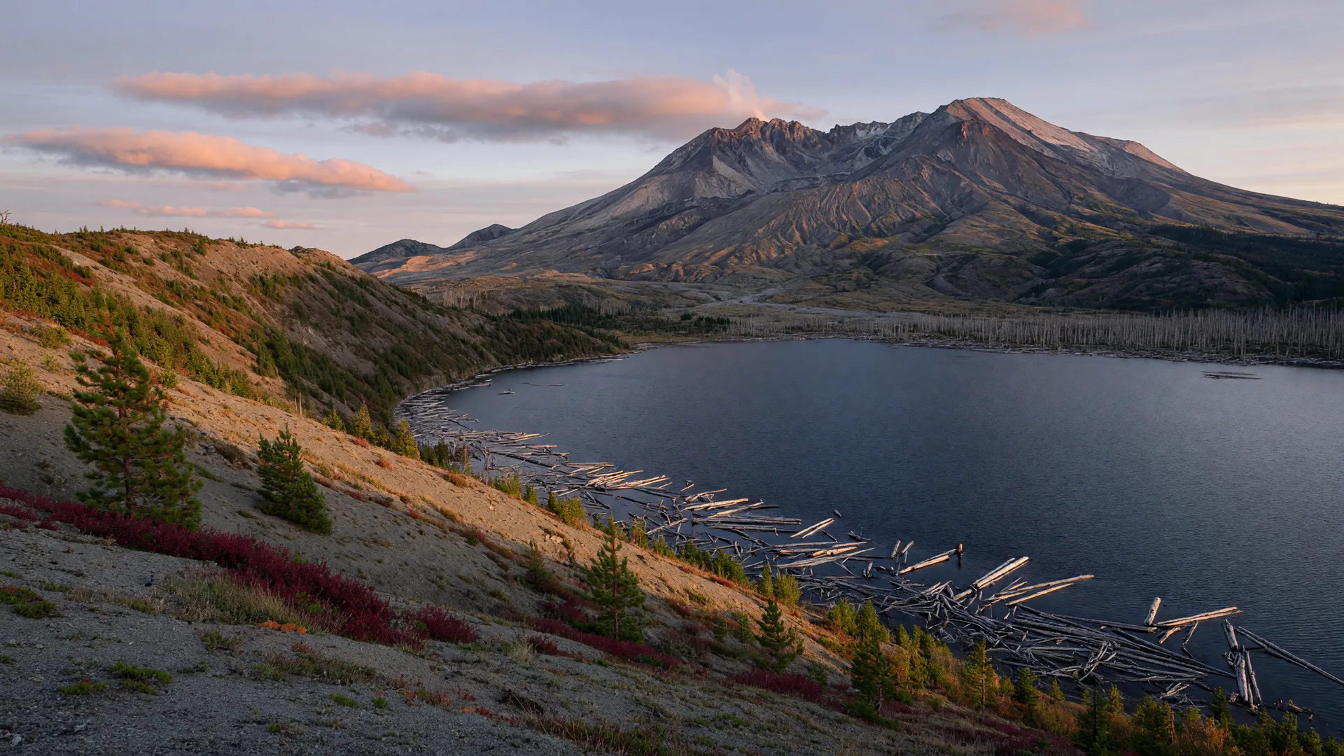
Want to stand closer to Mount St. Helens than almost anyone else this fall? Skip the crowded west side and point your car at Randle. The east side of the mountain, reached by forest roads out of Lewis County's own timber country, delivers the blast zone up close: a hike at Norway Pass with Spirit Lake laid out below, a short boardwalk at Meta Lake that tells the 1980 story in half an hour, and Windy Ridge, the high viewpoint that puts the crater almost within reach. Here is how to spend the day out there, with directions, difficulty, and the conditions that matter right now.
Where is this, and how do I get there?
The east side of Mount St. Helens lives at the end of Forest Road 99, and the way in is through Randle. From Randle, take WA-131 south out of town and watch for the signs to the Mount St. Helens National Volcanic Monument. After about a mile the road forks: stay right and it becomes Forest Road 25. You follow FR 25 south for about 19 miles through the Cowlitz Valley timber, turn right onto FR 99, and climb toward the mountain from there. The Meta Lake trailhead sits right at that junction, the Norway Pass trailhead is a few miles up FR 99, and Windy Ridge is at the road's end about 16 miles beyond. All told it is roughly 36 miles and close to an hour of driving from Randle to Windy Ridge, and nearly every mile past the pavement is gravel, so plan on a generous morning and give yourself time for stops.
Here is the piece of local knowledge that makes Randle the right gateway this season. Forest Road 25 is currently closed as a through-route well south of the FR 99 junction because of a large slide, so you cannot reach Windy Ridge from the Carson or Trout Lake side. That leaves the Randle approach, our approach, as the only road in, which means thinner crowds and a mountain that feels like it belongs to Lewis County. On the far side, State Route 504 remains closed at the South Coldwater Slide just past the Hummocks Trailhead, with Johnston Ridge out of reach by road until at least 2027 while the bridge is rebuilt. This year, if you want to face the crater, you come through Randle.
Norway Pass: the hike with the Spirit Lake views
Norway Pass is the hike people remember for years. The Norway Pass Trail (Trail 1) runs about 4.5 miles round trip with roughly 850 feet of gain, comfortable enough for the easy-to-moderate crowd, with the trailhead on Forest Road 26 just off FR 99. It climbs through the young forest that has regrown across the blast zone, and then the ridge opens and stops you cold: Spirit Lake filling the basin below, its surface still carrying the raft of logs the eruption swept in on the morning of May 18, 1980, and the gray bulk of Mount St. Helens rising beyond it. On a clear day you can pick out Mount Adams to the south and Mount Rainier to the north from the same spot, which is the kind of view that makes you just stand there for a while.
The trail tops out around 4,500 feet on the edge of the Mount Margaret Backcountry, so the air is thin and sweet and the September light is low and golden. This is huckleberry season out here, and the bushes along the upper trail are heavy with fruit, so bring a container if you like to pick as you go. The tread is well graded through most of the climb, with a few rocky stretches near the pass where poles help. Allow two to three hours round trip with stops, and remember that everything you see below you was rearranged in a matter of minutes forty-six years ago, which makes this one of the most dramatic half-day hikes in Washington.
Meta Lake: the short boardwalk with the eruption story
Right where FR 25 meets FR 99 sits the Meta Lake Interpretive Site, one of the best stop-for-everyone places on the mountain. The trail is a 0.6-mile loop, nearly flat on a boardwalk that is wheelchair and stroller friendly, and it is a perfect warm-up or wind-down for the day. Interpretive signs tell the story of May 18, 1980: this entire basin sat in the blast's direct path, and the forest here was flattened in seconds. The lake itself is famous for the survivors, rainbow trout that made it through the eruption beneath a protective layer of ice and snow, and the boards pass the charred snags and regrowth of the blast zone up close. Figure thirty to forty-five minutes for the loop, and linger at the viewpoints, the still water reflecting the broken trees is one of the most quietly haunting scenes on the mountain.
Windy Ridge: the drive-to viewpoint at the crater's edge
Keep climbing FR 99 to its end and you reach Windy Ridge, the monument's drive-up observation point at about 4,000 feet. A short paved path rises from the parking area to the viewpoint, and the scene stops people mid-sentence: Spirit Lake far below with its famous log raft, and beyond it the shattered northern flank of the mountain and the crater itself, with the lava dome that began building in the 1980s at its heart. On clear days you can sometimes catch a wisp of steam rising off the dome, a reminder that this is a living volcano. The road up is gated for winter and generally opens in early July after snowmelt, then stays open into November as weather allows, so a late-September visit lands right in the window.
One honest heads-up for 2026: the Spirit Lake infrastructure project, the tunnel outlet work that keeps the lake at safe levels, is active. That project brings weekday closures from May through October to some of the trails around Windy Ridge, including the old Windy Ridge summit trail, so the walk from the parking area can be interrupted on weekdays. The good news is that Norway Pass and Meta Lake are not part of that closure, and the simplest workaround is to plan this day for a Saturday or Sunday, when the work crews are off the trails. Before you commit, check the Gifford Pinchot alerts page or call the monument at 360-449-7800, conditions change fast in this country.
When is the best time to visit?
Late September is, honestly, the perfect window. The summer crowds have gone home, the huckleberries are ripe, the vine maple along the road is just beginning to turn, and the low autumn light makes the ash-gray slopes of the blast zone glow at golden hour. Mornings are genuinely cold at 4,000 and 4,500 feet, so layer up, and remember that the first October storms can dust the high country with snow, which closes FR 99 for the season. Your best odds anywhere on the mountain are a clear morning after a weather front has pushed through, with crisp air and views that carry for miles. If there is any smoke in the valley, check the air quality before you make the drive, hazy conditions are the one thing that can dim this show.
Passes, fees, and practical tips
- Carry a pass or cash: all three stops are fee sites. A Northwest Forest Pass or America the Beautiful pass covers you, or you can pay the daily vehicle fee at the pay stations (there are stations at Meta Lake, Bear Meadow, and Windy Ridge on FR 99).
- Drive a vehicle with clearance if you can: the gravel on FR 25 and FR 99 is generally passable in a passenger car in dry weather, but expect dust, potholes, and washboard, and slower going than the map suggests.
- Fill the tank in Randle or Packwood first: there is no gas, no food, and no phone service between town and the mountain. Screenshot your directions and download the trail map before you leave.
- Give yourself the whole day: the round trip from Randle plus the hike and the viewpoint stops comfortably fills eight or nine hours. Start early and you will not feel rushed.
- Pack layers, water, and patience for the road: temperatures swing hard between the valley and the viewpoints, and the last miles of gravel can surprise you. Bring a lunch and make it a picnic day.
- Respect the wild country: elk and black bears roam the blast zone. Keep your distance, carry out everything you carry in, and stay on the trails around the unstable slopes and cliffs.
Plan the day around it
Start early with coffee and a breakfast sandwich at Blue Stone Cafe on US 12 in Randle, then hit the FR 25 turnoff with a full tank. Do the Meta Lake boardwalk first while the morning birds are out, hike Norway Pass mid-morning when the light on Spirit Lake is at its best, and finish with the drive up to Windy Ridge in the afternoon, when the sun drops over the crater and the whole blast zone turns gold. On the way back down, pull off at the Bear Meadow viewpoint on FR 99, the spot where a small group of campers photographed the eruption cloud rolling out of the mountain on the morning of May 18, 1980, and end the day over a home-style plate at Roxy's Roadhouse back on US 12 in Randle. It is a long, satisfying day, the kind that makes you remember exactly why you love living here.
The west side of the mountain may have the visitor centers, but the east side has the views you remember: Spirit Lake below the crater, the blast zone stretching out like a frozen wave, and a road that ends right at the edge of one of the most dramatic landscapes in America. Come through Randle, and bring a camera.